Specs Fine Books
1877 U. S. SURVEY SAMMEBLAND. 20 + Reports on California, Monomy, Maps, & Cartographic Technology
1877 U. S. SURVEY SAMMEBLAND. 20 + Reports on California, Monomy, Maps, & Cartographic Technology
Couldn't load pickup availability
A fine working assemblage of United States Survey publications issued during the most scientifically ambitious period of its history and a significant volume in the history of cartographic research and practice. The Coast Survey was recognized as the chief scientific agency of the United States federal government, and these papers collectively demonstrate just how broad that mandate was: geodesy, geomagnetism, tidal science, hydrography, time determination, oceanographic chemistry, and pure mathematics were all in ongoing development under their leadership.
Because of the breadth of their work, the contributors read like a who's-who of 19th-century American science:
Benjamin Peirce was the Survey's previous Superintendent (1867–74) and is often regarded as the earliest American scientist whose research was recognized as world class. His New System of Binary Arithmetic is a curiosity of mathematical history, an early exploration of non-decimal number systems by one of America's greatest mathematicians, published while he served as Consulting Geometer to the Survey.
J. E. (Julius Erasmus) Hilgard, author of the zenith-telescope and personal-equation papers, was the Survey's de facto chief of operations for years and later became Superintendent himself in 1881. In 1875, he was president of the American Association for the Advancement of Science.
Charles A. Schott (magnetic declination, Atlanta baseline, Key West magnetism, Capitol Hill observatory) is described by the National Archives as the most significant unknown American scientist of the 19th century. His magnetic work was foundational to understanding Earth's field across North America, and he served as chief computer for 50 years, making him the person who made sense of the Survey's vast accumulation of data.
Henry Mitchell, Chief of Physical Hydrography, is represented by two papers: his classic study of Hell Gate (the treacherous tidal passage into New York Harbor) and his work on tide-land reclamation. His Hell Gate tidal analysis was essential to navigational safety in one of the world's busiest ports.
The assemblage, owned by Surveyor, W. J. Smith, contains more than 20 individual publications, including first releases and full page engravings of new technologies, updated and historically comparative maps, and more.
The papers span an extraordinary geographic sweep — from Monomoy on Cape Cod (with its remarkable comparative maps from 1606 to 1872 showing coastal change) to San Francisco Bay, Lower California, Key West, Atlanta, Alaska, and Mount St. Elias. The Alaska and Mount Fairweather paper is particularly notable: it represents early systematic American scientific attention to Alaska, which had only been purchased from Russia in 1867.
The Monomoy paper with its four-panel map (1606, 1853, 1868, 1872) is one of the earliest visual demonstrations of large-scale shoreline change in American scientific literature — essentially proto-coastal-geomorphology, showing dramatic peninsula migration over nearly three centuries.
The volume includes:
United States Coast Survey. Carlile P. Patterson, Superintendent. Methods and Results. The Closing of a Circuit Triangulation. Washington. Government Printing Office. 1877. 45pp
[With]
United States Coast Survey. Carlile P. Patterson, Superintendent. Professional Papers. Determination of Time, Latitude, and Azimuth. With an Appendix on Mount Saint Elias, Mount Fairweather, etc. Washington. Government Printing Office. 1876. 72pp + 32pp
[with]
Hilgard, J. E. On the Use of the Zenith-Telescope for Observation of Time. 69pp. [No title]
[with]
Appendix No. 8. On the Secular Change of Magnetic Declination in the United States and Other Parts of North America: New Discussion by Charles A. Schott, Assistant Coast Survey. 37pp.
[with]
United States Coast Survey. Carlile P. Patterson, Superintendent. Methods, Discussions, and Results. Notes on Measurements of Terrestrial Magnetism. Washington. Government Printing Office. 29pp.
[with]
Report on the Results from the Observations Made at the Magnetical Observatory, on Capitol Hill, Washington, D.C. between 1867 and 1869. Charles A. Schott. 9pp. [No title].
[with]
Mitchell, Henry. Chief of Physical Hydrography. Report on the Tides and Currents of Hell Gate, One of the Entrances to New York Harbor, Made to the Superintendent of the Coast Survey. Washington. Government Printing Office. 1869. 14pp
[with]
Mitchell, Henry. United States Coast Survey on the Reclamation of Tide-Lands and its Relation to Navigation. With an Appendix on the Tides in New York Harbor. Coast Survey Report. 1869 / 1875. 32pp + 28pp.
[with]
Jacobsen, Oscar. United States Coast Survey. On the Air Contained in Sea Water. Washington. Government Printing Office. 1874. 16pp.
[with]
Peirce, Benjamin. A New System of Binary Arithmetic. April, 1876. 6pp.
[with]
Measurement of a Primary Base-Line on Peach-Tree Ridge, near Atlanta, Georgia, in 1872 and 1873 by C. O. Boutelle - Computed and Reported by Charles A. Schott. 14pp.
[with]
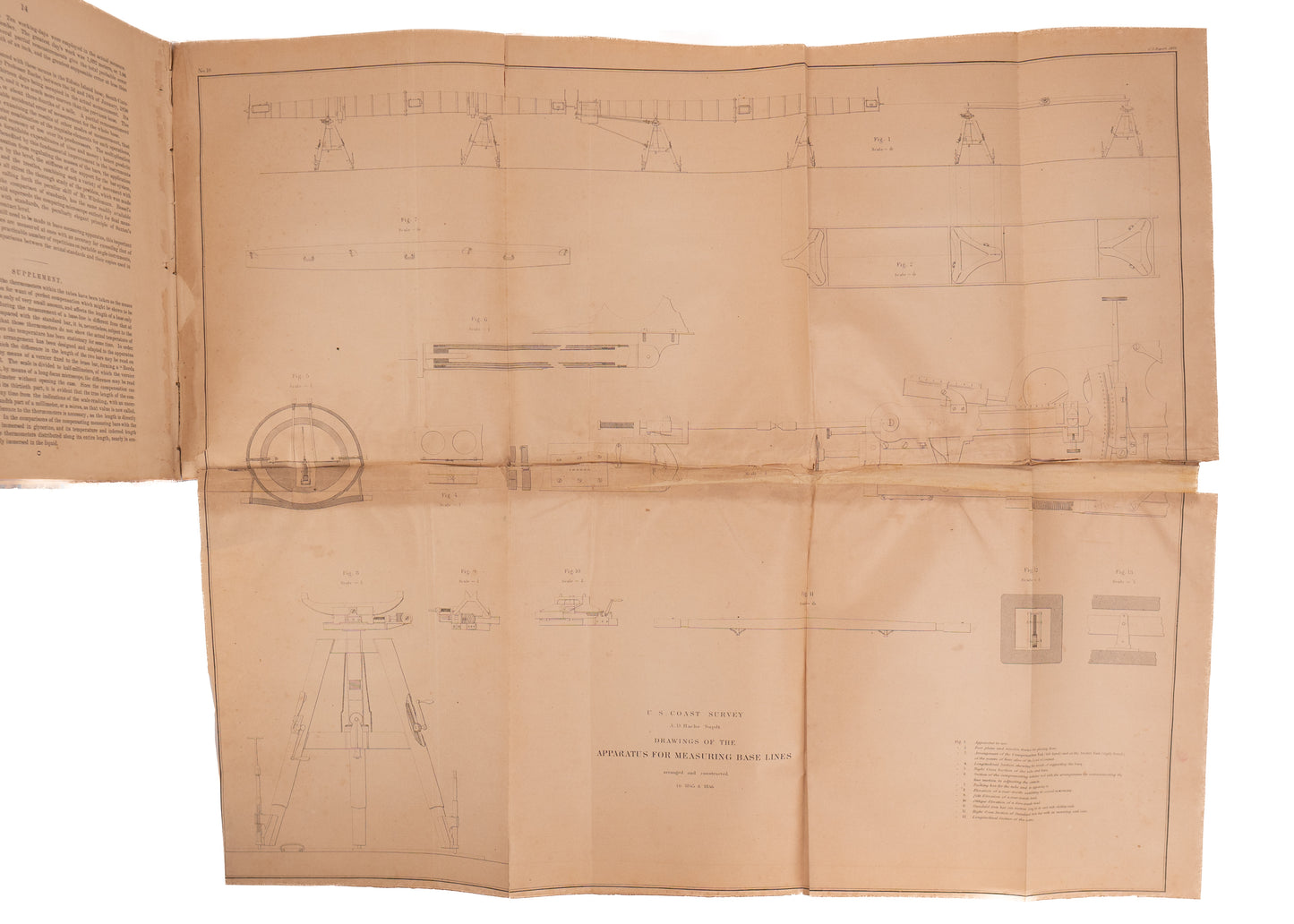
Description of an Apparatus for Measuring Secondary Base-Lines. 3pp. Nd.
[with]
A List of Stars for Observations of Latitude. 37pp. Nd.
[with]
Improved Clamp for the Telescope of the Theodolite. 2pp
[with]
Results of Observations of Terrestrial Magnetism at Key West, Florida, Made between 1860 and 1866 under the Direction of Prof. W. P. Trowbridge. 1874. 22pp.
[with]
Description of Two Forms of Portable Apparatus for the Determination of Personal Equation, both Relative and Absolute in Observation of Star Transits by J. E. Hilgard.
[with]
Abstract of a Paper Read before the National Academy of Sciences, April 16, 1869, on the Earthquake Wave of August 14, 1868.
[With]
On the Probable Effect of Extended Piers in Modifying the Channel Facilities of San Francisco Bay Near Yerba Buena Island. 2pp.
[With]
Extract from a Report to Professor Benjamin Peirce, Superintendent United States Coast Survey, Relative to the Method of Determining Elevations along the Course of a Tidal River Without the Aid of a Leveling-Instrument. 2pp.
[With]
Results of Observations for Determining Positions Occupied in Lower California. 3pp + full page map.
[With]
Results of the Telegraphic Determination of the Longitude of San Francisco, California. 1p.
[With]
On the Phosphate Beds of South Carolina, by Professor N. S. Shaler. 8pp.
[With]
Report to Professor Benjamin Peirce, Superintendent United States Coast Survey, Concerning Naussett Beach and the Peninsula of Monomoy. 10pp + folding map of Monomoy Chronological Maps Side by Side [1606, 1853, 1868, and 1872]
The whole very nicely preserved in a large original 4to half leather binding; some rubbing and wear as shown. Contents very good overall; the largest folding plate [more than ten panels] with some tenderness at folds and tears. Else crisp and clean. Very minor stain at upper right corner for last few signatures.
Share